The Fourth Wheel · A Companion to Book I, Part Seven
Eleven ringed places, and one at the centre that all of them answer to.
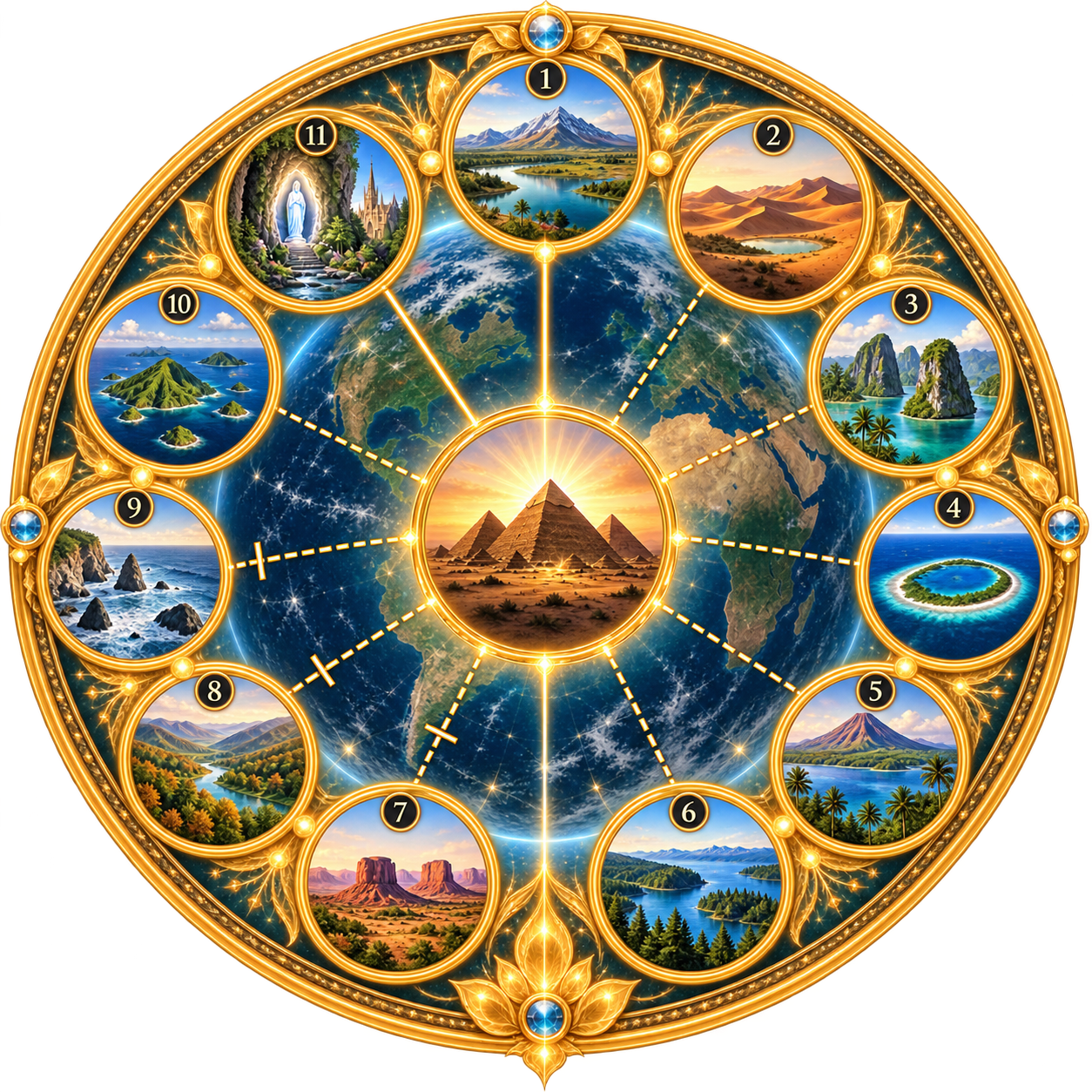
This Wheel is a companion piece to Planetary Time Warp Architecture, Book I — specifically to Part Seven, “The Twelve Artificial Time Warp Area Tests” (Chapters 23–34), where each of these twelve Areas is registered against Giza with its own coordinates, longitude and latitude tests, and stated precision. The Wheel does not introduce new locations; it is a visual index into work the Thesis has already done.
The image was generated independently of that chapter-by-chapter register, so the eleven outer circles carry no place names of their own — they are impressionistic landscapes, not site photographs. What identifies them is structural: eleven circles surrounding one centre, in an unbroken ring, matches exactly the Thesis's own count of Area One through Area Eleven surrounding Area Twelve. The centre circle — a pyramid rising in gold light — is unmistakably Giza, the reference datum every other Area's distance and bearing in this Thesis is measured from.
One outer circle removes any doubt about the sequence: circle 11, showing a robed figure at a grotto beside a waterfall with cathedral spires behind it, is a direct depiction of Lourdes — Area Eleven. That fixes the numbering running clockwise from the top (circle 1) around to circle 11, immediately to Giza's left.
The table below pairs each circle with its Area, its terrestrial control point and coordinates as registered in Book I, and a short note on how confidently the circle's imagery matches its Area. Most match by general landscape type — desert and lake for the Takla Makan–Lop Nor basin, coral atoll for Kwajalein, volcanic island for Hawai‘i — rather than by depicting the exact terrain. Lourdes alone is a specific, confident likeness.
Reading the Wheel: position corresponds to the circle's number in the image (1 at the top, running clockwise); Giza sits at the centre as Area Twelve and does not carry a position number of its own.
Each of the twelve Areas below now has its own page — a detail from the Wheel, the terrestrial control and coordinates, the WGS84 distance and bearing from Giza, and a short registration note drawn directly from Book I. Select any Area's name in the table to open its page.
| # | Area | Control & Coordinates | What the Circle Depicts | Note |
|---|---|---|---|---|
| 1 | Area One — Aral Sea · Kungrad | Kungrad, Uzbekistan 43.04°N, 58.84°E | River opening into an inland sea, fed from snow-capped mountains. | Kungrad sits on the Amu Darya delta at the Aral Sea's southern edge. |
| 2 | Area Two — Takla Makan · Lop Nor | Lop Nor, Xinjiang, China 40.50°N, 90.50°E | Desert dunes cradling a small pale lake. | Historic lake bed at the eastern edge of the Taklamakan Desert. |
| 3 | Area Three — Philippine Islands | Archipelago reference 12.77°N, 121.75°E | Turquoise lagoon ringed by limestone karst islands. | Source names the archipelago as a whole; a central point is used for testing. |
| 4 | Area Four — Kwajalein · Marshall Is. | Kwajalein Atoll 9.18°N, 167.31°E | Ring-shaped coral atoll in open ocean. | Largest atoll of the Marshall Islands group named by Key 215. |
| 5 | Area Five — Hawaiian Islands | Hawaii geographic centre 20.25°N, 156.33°W | Volcanic cone beside a crater lake, fringed with palms. | Also Satellite I and Gate I (Root) — the only Area with that triple overlap. |
| 6 | Area Six — Vancouver Island | Official island centre 49.63°N, 125.70°W | Still mountain lake held within dense temperate forest. | Pacific Northwest coastal-forest character, standing in for the island. |
| 7 | Area Seven — Pueblo to Mescalero | Pueblo CO–Mescalero NM 38.25°N,104.61°W / 33.17°N,105.60°W | Red sandstone buttes rising from high desert scrubland. | A two-point corridor across Colorado–New Mexico high desert. |
| 8 | Area Eight — Lexington to Tennessee | Lexington KY–TN proxy 38.04°N,84.46°W / 35.85°N,86.41°W | River winding through autumn-coloured forest. | A two-point corridor across the Kentucky–Tennessee uplands. |
| 9 | Area Nine — Nova Scotia to Bermuda | N. Scotia–Bermuda 45.00°N,63.00°W / 32.31°N,64.75°W | Rocky Atlantic coastline meeting breaking waves. | A two-point corridor spanning open Atlantic water. |
| 10 | Area Ten — The Azores | Azores bounds midpoint 38.32°N, 28.02°W | Volcanic island archipelago in turquoise Atlantic water. | Midpoint of the Azores' bounding geography, used as terrestrial control. |
| 11 | Area Eleven — Lourdes | Lourdes, France 43.09°N, 0.05°W | Robed figure at a grotto and waterfall, cathedral spires beyond. | The clearest of the eleven — a direct likeness of the Lourdes grotto and basilica. |
| — | Area Twelve — Giza (centre) | Giza, Egypt 29.98°N, 31.13°E | The Great Pyramid rising in gold light. | The datum: origin point for every distance and bearing elsewhere in this Thesis. |
Coordinates and control points are drawn directly from Book I, Chapters 23–34 (“The Twelve Artificial Time Warp Area Tests”). This table does not add new precision beyond what those chapters already establish.
This is the first of two Major Time Warp Areas: the Artificial Time Warp Areas above, drawn from Book I, alongside the Natural Time Warp Wheel drawn from Book II.
If you would like to reach us directly, please write through Inner Reception.